Monday, 22 March 2021

The Lost Church (Eglwys Fair) -- a Templar or Hospitaller connection?


We know that the Victorian church in Cilgwyn (now closed and used as a private residence) was built around 1880-84 as a replacement for an older church that was probably built around 1550, following the dissolution of religious orders. According to George Owen (1603) it was dedicated to St Mary the Virgin -- that was not at all unusual, although of course the "mother church" in Nevern was dedicated to our local saint, Brynach.

But what of the even older church on the side of Banc Du? It's recorded on the 6" map as "Eglwys Fair" (Mary's Church or the Church of St Mary) but which Mary? Was it the Virgin, or Mary Magdalene? Vanya suggests that there might have been a Templar link in this area, and that they had a special affection for dedications to St Mary Magdalene......

George Owen tells us that in 1603 there were no less than 8 pilgrimage chapels in Nevern parish, at the following locations:

Capel St Thomas, in Morfa quarter
Capel St Ffraid (St Bride) in Crugiau quarter
Capen Gwenfron, in Crugiau quarter (named after a female saint)
Capel Gwenddydd, in Crugiau quarter (named after a female saint)
Capel Reall (St Milburg's Chapel), on Banc y Capel (SN071392) near Llwyngwair Manor
Capel Padrig (a nice Irish connection)
Capel St George (Capel Cynon) at Roft-y-Capel, SN055344 near Tregynon (still marked on the OS map).  Also called Eskergynon.
Capel Cilgwyn (St Mary's Chapel), recorded as being assessed with Nevern in 1291 -- this must be the ruined chapel on Banc Du at SN076347 and marked as "Eglwys Fair"


They all had influential (and not necessarily devout) patrons, and they were used for solemn processions on holy days and as stopping places for pilgrims. Most were devotional chapels associated with religious cults -- in this area almost inevitably the cult of St Brynach. However, by 1603 almost all of them were in ruins. They were probably not "hermit's cells" like the little chapel of St Govan, although some -- like Eglwys Fair -- were in very remote locations.


The ruins of Capel Cynon or Capel St George, Tregynon, listed by Dyfed Archaeology as PRN 1571


Some of the ruined chapels in Pembrokeshire were conferred upon the Order of St John (Slebech Commandery) around 1150. And we also know that some of the ruined chapels (such as Parc yr Hen Gapel near Dinas Cross) were plundered by the removal of stone for the building of nearby farmhouses. Many old chapels became parish churches on the Dissolution of the Monasteries and Religious Orders.


However,  the name "Temple Bar" is found near Nevern, and the name "Felindre Farchog" might suggest some local link with the Templars, who were a military order set up in the context of the Crusades.  The alternative name for Capel Cynon -- namely Capel St George -- is unusual for this part of Wales, and might suggest a link with the Templars.  And Tregynon is not all that far from Banc Du.  But research suggests that the Templars didn't actually have much of a presence in Wales. As for the Commandery of Slebech, the lists of properties (including churches and chapels) belonging to it in 1230, 1338 and 1525 include just one burgage in Newport (Newburgh) and no properties at all in Nevern parish. (Source: Parry, 1996: The Commandery of Slebech in Wales of the Order of the Hospital of St John of Jerusalem.)  ET Lewis suggests that there were 15 acres of land at Berry Hill which were gifted to the Hospitallers;  but it's not known what they did with it.

We can therefore suggest that there was no strong presence in Nevern or Cilgwyn of either the Knights Templar or the Slebech Commandery in the 400 years prior to the dissolution of religious houses and orders in 1536-1540. It's most likely that the old church on the side of Banc Du was indeed dedicated to St Mary the Virgin.


Saturday, 20 March 2021

St Mary's Church -- lost and found


Thanks to Marc, Vanya and others, we think we have tracked down the site of the medieval Church of St Mary the Virgin (Eglwys Fair), on the side of Banc Du at grid ref SN 07680 34746. This was probably the church where Henry Tudor worshipped after landing at Dale, on 8th August 1485, and marching northwards. According to legend, he stayed at Fagwr (or Fagwyr) Lwyd, while his followers camped on the plateau west of Cnwc yr Hydd summit. Afterwards, he continued with his growing army via Newport and Cardigan up to Aberystwyth and then on to the fateful Battle of Bosworth in 1485.

The "lost church" is shown on the old maps as Eglwys Fair, but in the wrong place, to the west of the fence. It is actually below the old quarry shown on the satellite images, and although the piles of rubble / collapsed walls were still visible a century ago, now they are completely covered with turf.

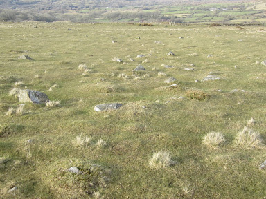
After a search, it has to be said that the signs of the old church are quite subtle. All we can see is a disturbed area on a grassy shelf about 20m from the old quarry. In an area about 7m x 7m there are a number of low hummocks about 80 cms high, with a slight hollow in the middle. On prodding the hummocks, I discovered that they are all located on boulders or piles of smaller stones. Some of these stones are loose -- and that indicated that this is all that is left of an old building. (If all of the stones were to be solidly embedded in the turf, that mightv indicate that they are very old glacial erratics, just as we find on the area west of Cnwc yr Hydd......)

Anyway, a little piece of local history rediscovered!


Some of the uncovered stones -- in a short space of time I was able to strip the turf off 13 of them.

We don't know how much time has elapsed since this old church became derelict. It was probably built some time in the early Middle Ages by a rich local patron, as a "chapel of ease" linked to Nevern -- and maybe used by travellers and by parishioners who found the journey to Nevern too daunting. How big was it? Well, there is a faint impression that shows up in satellite images suggesting a rectangular building c 15m x 5m, aligned approx N-S. I suspect that it fell into disrepair in the middle 1500's, when a new Church of St Mary the Virgin was built in its present location, down next to the river in Cilgwyn. When the building collapsed, I suspect that some of the stone might have been cannibalised and used for the cottage called Penlan-Oleu, a short distance to the east, across the fields.

PS.  More interesting info from Vanya:

from Archives: Site of St. Mary's Church (Eglwys Fair) .
Royal Commission for Ancient Monuments in Wales & Monmouth 1914:
The site of the little chapel of St Mary is reputed to be the summit of Banc du, at the foot of which, 3/4 mile to the north is the present chapel of St Mary Cilgwyn.
About the year 1900 The Pembrokeshire Archaeological Survey reported upon the few remains then visible as follows:
"They consist of large stones forming three sides of a rectangular figure. There is no trace of mortar but in several places both faces of the foundation of wall or hedge are visible, and judging by the size of the stones, some of which are very large, the building, if building it was, must have been very ancient. The east side of the enclosure measures 21 yards and the north side 19 yards. The south side measures only 9 yards but it is possible the stones may have extended further westward and that they are concealed by a mound of rubbish excavated from the neighbouring quarry. The curious feature is that the greatest length is from North to South; whereas in a church one would expect to find the building longest from east to west. The ground rises from the east side of the enclosure so that it would seem that the west wall if there was one must have been below the level of the contour of the land which slopes from the quarry to the east "

Father Gildas from Caldy Monastery has studied early Celtic Christianity extensively and thought it could be an early chapel as their orientation was North west. Rather like the earlier chapel to the North of Nevern Church. That too is built in a similar fashion very like St Govans Chapel in South Pembrokeshire. It would be interesting to compare the dimensions of the three of them.

That's intriguing, suggesting the the western side of the church was below ground level, which is indeed sloping below the edge of the quarry, and that there was a sort of platform on which the church was built.  The enclosure within which the church was built has been lost without trace.  There is also a suggestion that the quarry post-dates the church.  That fits with my assumption that this quarry, like the others on Cnwc yr Hydd, was opened up in the eighteenth and nineteenth centuries to provide shale and mudstone slabs for local buildings and walls. 

PS.  3rd April 2021.   The mystery deepens -- at the "new" site of St Mary's Church Cilgwyn Maye (who now lives there) has pointed out to me that there are at least two inscribed stones with crosses which are quite discernible.  One stands close to the porch, and the other is built into the fabric of the church, at its NE corner high above the ground.  Stones such as these are generally assumed to date from around 800 - 1000 AD -- so if the stones were carved and used on this site, that suggests the presence of a chapel in the early Middle Ages, possibly used at the same time as the other "Eglwys Mair" high up on the slope of Banc Du..........

Saturday, 13 March 2021

Whitesands


 A fabulous image of Whitesands, published on Facebook by Emyr Afan of Avanti Media.  Worth sharing!

Wednesday, 10 March 2021

The lost church of St Mary the Virgin


On a Facebook group  page I have been discussing with Vanya Orr and others the fate of the “missing church” of St Mary the Virgin (Eglwys Fair) up on the mountainside near Banc Du, at the top of the Garfeth track that leads up from Cilgwyn. There is nothing there at the moment, apart from a name on some old maps. The problem is that it is easy to confuse it with the other St Mary’s Church, down in the valley in Cilgwyn, which is a Victorian building dating from 1880. It’s now a private residence,  having been deconsecrated some years ago. Before the Victorian rebuild there was a church there, but it was derelict. George Owen (1603) said that the church on this site was “consecrated within living memory” — which probably means around 1550.

Before that, the church dedicated to St Mary seems to have been up on Banc Du. We don't know who built it, or when — but it was probably erected by a wealthy patron some time after the establishment of the Barony of Cemais.  It was recorded as a "chapel of ease” connected to Nevern Church in 1284, but it may have been used mainly for private worship. Was it built of wood, or stone? Was it destroyed and rebuilt in this exposed and vulnerable place during the centuries of conflict between the Anglo-Normans and the Welsh princes? Maybe over and again? And where exactly was it located?  And was it connected in some way to the medieval "deer park" that is known to have existed on Waun Mawn?  The old maps show it on the slope of the hill above the old quarry — but Vanya thinks that it might have been located on the flatter ground below the quarry — and there is indeed a very faint rectangular shape there, visible on satellite images, measuring c 15m x 5m, and aligned approx N-S.

Another clue to the existence of this little church or chapel comes in the story of Henry Tudor and his march from Dale to Bosworth Field. In August 1485 he passed this way, and tradition has it that he camped with his growing army at a place called “the fifth milestone”. That might well have been on the plateau near the summit of Cnwc yr Hydd, which is spacious enough and dry enough to accommodate a substantial encampment involving horses, men and their supplies. Tradition also has it that Henry slept at Fagwr Lwyd and that he worshipped at the church of St Mary. Those three locations, within a kilometre of one another, suggest to me that the tradition is a reliable one. The trackway leading down to Garfeth and then onwards to Cilgwyn and Newport is also a very substantial if ruinous lane, and we can speculate that this might well have been the main road leading from Haverfordwest to Newport.

It would be rather exciting if we can establish where this “lost church” was actually located……..


The dolerite plateau to the west of Cnwc yr Hydd summit.  Was this the upland meadow on 
which Henry's army camped on the night of 8th August 1485?

Monday, 8 March 2021

The "one night houses" that lasted for five generations


I'm increasingly intrigued by these little buildings and enclosures on the edge of the common land in the Newport area. The top one is called Ty-Col, and is near the Bedd Morris standing stone to the west of Newport Pembs. The other is called Pen-lan-Oleu, and is to the north of Cnwc yr Hydd, near Tafarn y Bwlch. I assumed they were both "ty unnos" or "caban unnos" buildings originally, given their locations, and I guessed their date of construction to be around 1810. The latter one was still inhabited in the Second World War -- as was the building called Carningli Lodge, on the edge of the common near Carningli. 

So I guessed that these ruins had survived as viable places of residence for 5 generations -- which is much longer than many of the "illegal" houses build on the edges of the commons in other parts of the UK. They are classic longhouse designs, with stable, cowshed and pigsty at one end of the row, and the human habitation at the other end.

Anyway, I put out a request for information on the Heritage and History of Wales Facebook page, and in no time at all I had many replies.  This is what I got from Ceridwen Cilshafe on the subject of Ty-Col:  This 15 acre holding is mentioned in the 1584 Bronwydd papers, and was probably linked to the Cole family of Llwyngwair. The ruins indicate a longhouse, 108’ x 18’ in plan, and a small out- building. Reg Davies concluded that the longhouse contained a pig-cote, cow-house, a 30’ cottage and a barn. It may originally have been a Hafod, and there is a Hendre one mile NNE. The old Drovers’ Road passes 500 yards to the east. However, census records show that from 1841 to 1911 it was a dwelling for the Evans, Williams, Owens, James and Howells families. By 1933 Ty Col was in ruins. (info from Len Urwin)

I suppose its possible that Ty-Col was in more or less continuous occupation from around 1584 to around 1930.   So it's been in ruins for around a century.  The stonework is very rough indeed, and the walls are in a dangerous state; almost all of the mortar that was used has been washed away.

We must clearly be careful about labelling things on the basis of their location on the edge of the common! That having been said, I still think Pen-lan-Oleu is probably a "ty unnos" dwelling........

We like to think that "one night" cottages are unique to Wales -- but that's not true. Almost every country in the world seems to have a tradition that landless people (or young couples with no money) can secretly build a cottage overnight on waste land or common land, and get away withy it, on the grounds that some ancient law allows it.  When you look for these ancient laws, they don't actually exist -- so the tradition probably arises from a resentment against landowners with wealth and power who presume to own land which others think should be part of the "commons"...........

In his book "Cotters and Squatters" Colin Ward says that the great majority of "overnight cottages" built in the British Isles were destroyed shortly after they were built, either by vengeful landowners who felt that their authority was being threatened, or by landowners intent on enclosing parts of the common (with or without Parliamentary approval), or by commoners who felt that with every reduction in the size of the common their own use of it for grazing, peat cutting, and rush gathering was compromised.  So although many of the cottagers were supported by a wide circle of family and friends, it was not guaranteed that ALL of the poor people and tenant farmers of a district were in favour of the incremental shrinking of the common land that was essential for their own survival. 

So if some older building like Ty-Col and some newer ones like Pen-lan-Oleu managed to survive on the edges of the common, while others across the UK were demolished almost as quickly as they were erected, what was different here in Pembrokeshire?  I suspect that there might have been several factors at play:

1.  The fact that the Barony of Cemaes -- a medieval institution -- still owned the commons of Carningli, Dinas and Preseli.

2.  The ruinous nature of Newport Castle and the absence (for most of the time) of the Lord Marcher, leaving things in the hands of rather inefficient stewards who had some sympathies with the aspirations of tenants and landless families.

3.  There were no other large and powerful families in the area who owned estates on the edges of the common and who sought to enlarge them via common-land enclosures.

4.  The enclosures were generally for the benefit of "small" families rather than large estates, which meant there there was not the same level of animosity from the commoners that might have been expected if there had been "land grabs" by unpopular members of the gentry.

5.  The "pressure"on the commons was reducing rather than building up, in the period after 1830, as people left the area to search for a better life in the growing industrial centres on the South Wales Coalfield.  (In the period immediately after the Napoleonic Wars there was a local population increase, with the margin of cultivation moving uphill on the mountain slopes into areas that were very marginal in terms of climate and soil quality.  But when people started to emigrate eastwards that trend was reversed, and many "new fields" were abandoned and allowed to revert back to wilderness.  We can still see them in the landscape today.)

Paul Sambrook kindly reminded me that the Barony seems to have had a policy of allowing cottagers to build on the edges of the common, and that they collected rents on the buildings once they were habitable.  So the environment for settlers was not nearly as hostile here as it was in other parts of the UK -- and even around the lowland commons of Pembrokeshire.  I'll speculate that more cottages (maybe called "ty unnos" cottages and maybe not) were built around the Carningli and Preseli commons, and more of them survived, than might have been expected -- because of this rather unique set of local circumstances.  On the other hand, of course many of them were build in very remote and difficult locations in which "smallholder life" was very tough indeed -- and eventually it was inevitable that they would be abandoned.  But some of them --like Cot Llwyd -- survived and thrived!

PS  Here is an interesting entry:


Friday, 5 March 2021

The Ty Col longhouse


 Grid Ref  SN 030 370.  This is one of the most interesting ruined houses on the edges of the common -- not far from the Parc Mawr tors, and reachable along the moorland track that leads westwards and then north-westwards from Bedd Morris.  I suppose that we had better assume that it dates from the early 1800's, like most of the "ty unnos" cottages on the fringes of the moorland -- but this one is more complex and more interesting than any of the others.  It has a very intriguing pattern of enclosures around it, and it is approached by a beautiful little lane flanked by massive stone walls.  This is a landscape littered with huge dolerite boulders, and the buildings are settled on top of some of the largest.  

This is the closest approximation I have seen to a traditional Celtic longhouse, with five rooms in a row, with the dwelling house at the south end and with traces of a traditional "simnai fawr" and cwtch against the southern gable end.  At the north end there are what appear to be a small stable, a cowshed and a pigsty.  The walls are very crudely built with rough stone (all dolerite) blocks roughly shaped or dressed, and with minimal use of mortar. The main entrances face west, and there is one old door that has been blocked in with stonewalling.  So there are at least two phases of development.  

The dwelling is in a dangerous state, and there are no traces of a roof or an upper storey.  Some of the walls on the east side are leaning dangerously, and will soon collapse.

I wonder if the building is listed, or should be.....??


See also:

https://brian-angelmountain.blogspot.com/2020/11/another-romantic-ruin.html